Friday, May 2, 2025

Cape Cod

Cape Cod Community College

Take Exit 6 on Rt. 6 ( mid-cape Highway)
Turn onto Rt. 132 North
Take the second driveway into the college ( no parking allowed on Rt. 132)
Take the second driveway into parking lot #12
Follow the paved walk to the fields

Carver

Carver Middle School
Purchase Street Field
Field located 1/4 mile down on the right from the stop light at Purchase St. and Main St (Rt 58). Refer to the Middleboro Purchase Street map in the Coastal book. The Carver Purchase St fields are 1/4 mile from the Rt 58 and Purchase St. intersection in Carver.

Cohasset

Field A:
Take Rt. 3A south into Cohasset. Just past the Stop and Shop plaza take a left at the lights onto Pond st.
Cohasset High school is on the left. Take a left onto Bancroft Rd.
The field is located on the left. Parking is limited.

Field B:
Take Rt. 3A south into Cohasset. At the mobile station Just before the Stop and Shop plaza take a left at onto Sohier st.
Deer Hill school is on the right.

Duxbury

Chandler School: (see map to the right)
Head south on Main St/RT-228 toward S Pleasant St
Continue to follow RT-228 3.3 mi 7 mins
Merge onto RT-3 S via the ramp to Cape Cod/Plymouth 12.4 mi 13 mins
Take exit 11 for RT-14 W toward W Duxbury/Pembroke 0.2 mi
Turn left at Congress St/RT-14 466 ft
Turn left at Chandler St 1.8 mi 5 mins
93 Chandler St
Duxbury, MA 02332


Lincoln Street field
Head south on Main St/RT-228 toward S Pleasant St Continue to follow RT-228 3.3 mi 7 mins
Merge onto RT-3 S via the ramp to Cape Cod/Plymouth 12.4 mi 13 mins
Take exit 11 for RT-14 E toward Duxbury 0.2 mi 0.2 mi
Merge onto Congress St/RT-139/RT-14.
At the traffic circle, take the 3rd exit onto Lincoln St 0.8 mi 2 mins
540 Lincoln St, Duxbury, MA 02332

Halifax

Jr. High School Fields
Summit Street Fields:

From the intersection of Routes 58 and 106 (Walmart is on the corner):
Take Route 106 West. You will pass the Halifax Elementary School and then the Police Station (both on your left). Continue following Route 106 until you see Route 105 (also on your left). Take Route 105 (Thompson Street) and follow for approximately 2 – 3 miles until you see Summit Street on your right. Take a right on Summit Street and the fields are approximately a mile up on the right.


From Route 18:
Take Route 106 East. After 2 – 3 miles you will pass the East Bridgewater YMCA on your right. After another 2 – 3 miles, you will enter Halifax and will pass the Halifax Industrial Park on your left. Continue East on Route 106 until you see Route 105 on your right. Take Route 105 (Thompson Street) and follow for approximately 2 – 3 miles until you see Summit Street on your right. Take a right on Summit Street and the fields are approximately ? of a mile up on the right.

NOTE: The fields are located in a residential area so don’t be concerned if all you see are houses and open fields !!!

Hanover

 Hanover High School Cedar St. Field         Hanover Center School ( Silver St.)


 Hanover Gallant Field    Myrtle Field, Myrtle Street
     Take Route 53S, past Hanover Mall
Take Right onto Route 139 (at light just past Shaw’s)
Take Left onto Center Street (just after Town Hall)
At stop sign, take right onto Myrtle Street
Parking Lot will be on Left 

Hull

Sullivan Field/Dust Bowl (U10 & U12 games)
Rt 3 to EXIT 14 Rt. 228 Nantasket/Cohasset
Take Rt 228N following signs for Nantasket/Hull
This will bring you to Nantasket Beach (approx 15mins from exit 14)
Follow Nantasket Ave past the beach, (the Clarion Hotel will be on your left.)
At the first fork bear LEFT (Cumberland Farms will be on your left)
Follow through the center of town, you will pass through the alphabet streets (A St-Y St.)
At Y St, bear LEFT at the fork so that the water is on your immediate left ( don’t go up the hill) you will see a blue sign for the LIBRARY. Follow past the Saltwater Club and Hull Yacht Club on your left At next fork bear LEFT (Water Treatment Plant will be on your right) Follow past Spinnaker Island condos on your left. Continue on this road (past Hull Library on your left) The Coast Guard Station will be on your left as the road turns right The field is on your RIGHT Hull High School (U14 games) Continue on this road to the end, high school field will be on your right 

Kingston

Kingston Intermediate School Fields 

KIS Fields are located behind the school building at 65 Second Brook Street. From exit 9 off route 3 South - take right off  ramp and go through set of lights. Take left at next set of lights (bottom of hill at the Jones River) onto Brook Street. Bear left, almost immeditately, onto Second Brook Street. Follow to end. KIS is first school on right, fields are out back.  65 Second Brook Street, Kingston, Massachusetts 02364

Norman Opachinski Field Complex (Pottle St. Fields / Rizzo Field)
 Pottle Street is located in Kingston center, just off Summer Street (Route 3A) near the train tracks. From the north: Take Route 3 south to Exit 10. Take a right at the end  of the ramp. At the traffic light, take a left onto Route 3A south. Follow .9 miles to Pottle Street (on the right, just before the railroad tracks).

From the south, take Route 3 north to Exit 9. Take a right at the end of the ramp onto Main Street (Route 3A north). Follow .9 miles (Main St. turns into Summer Street). Just after the railroad tracks, turn left onto Pottle Street. The field complex  is a the very end of the road. Pottle Street, Kingston, Massachusetts 02364 
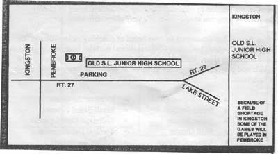
Kingston has a good map on their website


Marshfield

Field One (MHS1) 

Field 1 is in front of Marshfield High School, adjacent to Forest Street (also known as the “Varsity Field”). Marshfield HS is located at 167 Forest Street in Marshfield. 

MHS: From Rte 3, take exit 12 and head toward Marshfield (Rte. 139 South).
 Take a left on Furnace St. Take a left on Forest St. High School is on left and Field 1 is in front to the left as you face the school. 

Field Two (MHS 2)
 Field 2 is behind the MHS adjacent to the track and football stadium. Parking lot can be accessed from both Forest Street and Rte 139.

Grace Ryder (GR) Field - Field Three (GR 3)
 Grace Ryder Field is located on Rte 3A in Marshfield across from the Marshfield fairgrounds and just north of Marshfield Center and the merge with Rte. 139. 


Governor Winslow (GWS) Field - Field Four (GWS 4)

Governor Winslow Field is located behind the Governor Winslow Elementary School on Regis Road. Follow Rte. 139 east into Marshfield Center. At the stop light (CVS is on the left) bear right onto Webster Street (skate park will be on your left after turn). Follow Webster to the end. Make left and then immediate right onto Regis Road. School is at the end. DO NOT PARK IN FRONT OF RESIDENCES ON LEFT SIDE OF REGIS ROAD.

Middleboro

Purchase Street Fields: (U10 + U12)

South on Main St. 228
 Rt. 3 south to Plymouth/Cape Cod
 Merge onto US-44 W via exit 7 toward Taunton/Providence RI
 Take the Rt 58 S exit toward Carver
 Turn left onto N Main ST/ MA - 58
 Turn Right onto Purchase ST.
 Field is located on left hand side. It has a very small sign hidden the bushes that says MYSA.
 Proceed up dirt driveway to field.
 Healy Complex (Nyes Way)


Middleboro Riverside Field: (U14 and U16)

MA-3 S toward PLYMOUTH/ CAPE COD. 18.9 mi
Merge onto US-44 W via EXIT 7 toward TAUNTON/ PROVIDENCE RI. 10.9 mi
Turn LEFT onto PLYMPTON ST/ MA-105. Continue to follow MA-105 1.7 mi
Turn LEFT onto N MAIN ST/ MA-105. 1.0 mi
Turn LEFT onto E GROVE ST/ MA-28. 0.4 mi
End at 45 E Grove St Middleboro, MA 02346-180

          
 Middleboro Westfield School Field    Middleboro High School


Norwell

East Field (Town Hall)

Osborne Fields

Take Rt. 53 S from Hingham at intersetction of rt. 53 and 123 at Assinippi Corner... Take 123E (toward Scituate) for just over 2 miles. Fileds are on the right, Just before Norwell Middle School. Entance is just past fields. Please use School  parking lot. Do not park in road alongside of fields.


Pine St. Field

 Take Rt. 53 S from Hingham at intersetction of rt. 53 and 123 at Assinippi Corner... Take 123E (toward scituate) for about 3 miles. Turn right on to Circuit St. After about 1 mile take a right onto Pine St. Fields are immediately on the left opposite Council on Aging.


Norwell Middle School

 Take Rt. 53 S from Hingham at intersetction of rt. 53 and 123 at Assinippi Corner... Take a left onto 123 E. Drive about 2 miles and Middle school is on the right. It is behind the Sparrell school. Norwell HIgh School (South St.). Take Rt. 53 S from HIngham at intersetction of rt. 53 and 123 at Assinippi Corner... Take 123E (towards Scituate) for about 1 mile. Turn right onto South St. Turn right again quickly in to Norwell High School. Park in area near tennis courts and follow path to fields.


 Norwell Junior High    Norwell East

Pembroke

Plymouth

Forges Field Recreation Area field 1 and 2

Traveling Route 3 South take exit 5, at end of ramp turn right. Follow Long Pond Road for 2.7 miles to Jordan Road on the left. Follow Jordan Road for 0.8 miles to Forges Fields Park entrance on the right.


West School Fields

Traveling Route 3 South take exit 7, at the end of the ramp turn right. Follow Commerce Way to Route 80 / Plympton Road. Turn right at end of Commerce Way onto Route 80 and drive 1/3 mile West Elementary is on left.


Elmer Raymond field

Traveling Route 3 South take exit 2, at end of ramp turn left. Follow Herring Pond Road to the Red School House and turn right onto Long Pond Road. Follow Long Pond Road approximately 500 feet and turn right into Elmer Raymond.


Plymouth Nelson Street Field


Plymouth Cold Springs Field


Plymouth Indian Brook School Fields


Plymouth Manoment Elementary School

Plymouth South Elementary School

Plympton

Sacred Heart

Scituate

Scituate High School Field A

Take route 3A towards Scituate. Just before the intersection of First Parish Road is the turn-off for Scituate High School. It is just before the Police Station. 


Scituate Central School Fields

Scituate Jr. High School Field / C. Gates 


Take route 3A towards Scituate. After you take a left onto first parish road, you will come to the JHS on your right, and the first right after you pass the school is the road that leads to the only soccer field at the school Cushing School Field.